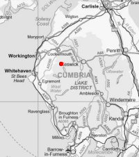
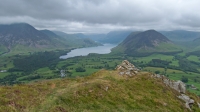
Low Fell
Height: 423m/1,387ft
Grid Reference: NY137226
Lists: FRCC (216) Wainwright (W.33)
Ascents: 7
Wainwright's top is south of the fence at NY 136222, 412m (1,351ft) approximately 1,360ft per Wainwright.
The highest point on the fell per the OS 1:25,000 map is north of the fence at NY 137226, 423m (1,387ft).
Wainwright thought that the northern top looked higher but the 2.5 inch OS map only had a ring contour at 1,350ft for both tops and the south top had the bigger cairn.
Sat 27 Jun 2015 - Fellbarrow and Low Fell
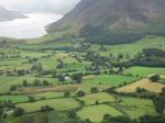
Loweswater car park - old road to Mosser - Fellbarrow - Smithy Fell - Low Fell - Low Fell (south top) - Darling Fell - old road to Mosser - Loweswater - Loweswater car park [5.75 miles 1,600ft ascent]
Mon 29 Dec 2008 - Fellbarrow and Low Fell
Loweswater car park - old road to Mosser - Fellbarrow - Smithy Fell - Low Fell - Low Fell (south top) - Darling Fell - old road to Mosser - Loweswater - Loweswater car park [5.75 miles 1,600ft ascent]
Sat 19 Aug 2006 - Fellbarrow and Low Fell
Loweswater car park - old road to Mosser - Fellbarrow - Smithy Fell - Low Fell - Low Fell (south top) - Darling Fell - old road to Mosser - Loweswater - Loweswater car park [5.25 miles 1,600ft ascent]
Tue 20 Jul 2004 - Fellbarrow and Low Fell
Thackthwaite - Fellbarrow - Smithy Fell - Low Fell - Low Fell (south top 412m - Wainwright top) - Foulsyke - Loweswater Village [4.25 miles 1,500ft ascent]
Loweswater Village - Low Fell - Loweswater Village [2.75 miles 1,100ft ascent]
Tue 8 Jan 2002 - Low Fell and Fellbarrow
Loweswater car park - old road to Mosser - Darling Fell - Low Fell (south top) - Low Fell - Fellbarrow - Mosser / Loweswater old road - Loweswater car park [5.25 miles 1,600ft ascent]
Wed 1 Jan 1992 - Fellbarrow and Low Fell
Pardshaw Hall - Cringley Hill - Hatteringill - Fellbarrow - Smithy Fell - Low Fell - Darling Fell - Mosser - Pardshaw Hall [7.75 miles 1,900ft ascent]