Wainwright Memorial Walk
[[Picture:1454|S|Right|Wainwright memorial plaque, St James Church, Buttermere]]
Wainwright's Walking Tour in the Lake District
'This tour is a most comprehensive one. Limited as we are by time, it is impossible to visit every corner of Lakeland, yet this programme, if followed conscientiously, will lead us everywhere worth mentioning.
It will be ARDUOUS, but the reward will be well worth the work. It will avoid the tourists, the roads, the picnic-spots.
It is the claim of this programme that EVERY lake, EVERY valley, EVERY mountain, will be seen if not actually visited.'
A. WAINWRIGHT, 1931
The above are AW's words on his proposed walking tour in the Lake District, Whitsuntide 1931. The plan was to do a six day trip around the Lakes with three colleagues from the Borough Treasurer's office in Blackburn where he worked at the time, the route was 102.5 miles long with 38,850ft of ascent. In the end they did not manage the full route having to leave out climbing Blencathra, Grasmoor and Pillar and took seven instead of six days.
Anne and I are trying to do the walk during 2007 to mark the centenary of AW's birth, we expect to take more than seven days.
There are a couple of books on the the walk:
- 'Wainwright's Tour in the Lake District', a coffee table book published in 1993 with photos by Ed Geldard. The book includes an introduction by W.E. Maudsley one of the walkers in 1931. Published by Michael Joseph.
- The second book is a guide to the walk published in 1998 called 'The Wainwright Memorial Walk'. The guide splits the walk into eleven stages, each with more realistic mileages than the punishing six day schedule set by AW. This does however increase the walk from 102 to nearly 124 miles with the additonal drops back to the valley and returns to the tops at the start of following legs. The six day schedule combines days 2,3 and 4 into one, days 5 and 6 into one, days 7 and 8 into one and days 9 and 10 into one. Again published by Michael Joseph.
AW's proposed route over six days is detailed below along with links to the walks we have undertaken to complete the tour.
A Wainwright's Itinerary
Day 1: Windermere to Patterdale
| Route | Time (hours) | Mileage | Ascent (ft) |
|---|---|---|---|
| Orrest Head | 0.25 | 0.50 | 400 |
| Windermere Reservoir (Dubbs Reservoir) | 0.75 | 2.25 | 550 |
| Garburn Pass (summit) | 2.00 | 4.50 | 1,250 |
| Yoke | 3.00 | 6.50 | 2,100 |
| Ill Bell | 3.50 | 7.25 | 2,450 |
| Froswick | 3.75 | 8.00 | 2,650 |
| Thornthwaite Crag | 4.25 | 9.25 | 3,100 |
| High Street | 4.75 | 10.25 | 3,400 |
| The Knott | 5.00 | 11.50 | 3,600 |
| Angle Tarn | 5.50 | 13.50 | 3,600 |
| Angletarn Pikes | 6.00 | 14.00 | 3,850 |
| Patterdale | 6.50 | 16.00 | 3,850 |
Day 2: Patterdale to Keswick
| Route | Time (hours) | Mileage | Ascent (ft) |
|---|---|---|---|
| Grassthwaite Howe | 0.25 | 0.75 | 300 |
| Striding Edge | 2.00 | 3.00 | 2,750 |
| Helvellyn | 3.00 | 4.00 | 3,118 |
| Helvellyn Lower Man | 3.25 | 4.50 | 3,150 |
| Raise | 3.75 | 5.75 | 3,550 |
| Sticks Pass | 4.00 | 6.25 | 3,550 |
| Stybarrow Dodd | 4.25 | 6.75 | 3,850 |
| Watson's Dodd | 4.50 | 7.50 | 3,900 |
| Great Dodd | 5.00 | 8.50 | 4,150 |
| Calfhow Pike | 5.25 | 9.50 | 4,200 |
| White Pike | 5.75 | 10.50 | 4,500 |
| Wallthwaite | 7.00 | 14.25 | 4,500 |
| Scales | 7.25 | 15.00 | 4,800 |
| Sharp Edge | 9.00 | 17.00 | 6,300 |
| Blencathra | 10.00 | 18.00 | 6,900 |
| Threlkeld | 11.50 | 20.00 | 6,900 |
| Bus to Keswick |
Day 3: Keswick to Buttermere
| Route | Time (hours) | Mileage | Ascent (ft) |
|---|---|---|---|
| Portinscale | 0.25 | 1.00 | 50 |
| Catbells | 2.00 | 4.00 | 1,500 |
| Maiden Moor | 2.75 | 5.00 | 2,200 |
| Eel Crags (High Spy) | 3.25 | 6.00 | 2,550 |
| Dalehead Crags | 3.50 | 7.00 | 2,550 |
| Dale Head | 4.00 | 7.75 | 3,200 |
| Hindscarth | 4.50 | 9.00 | 3,400 |
| Robinson | 5.25 | 10.00 | 4,000 |
| Newlands Hause | 6.00 | 11.00 | 4,000 |
| Knott Rigg | 6.75 | 11.75 | 4,700 |
| Ard Crags | 7.25 | 12.75 | 4,900 |
| Sail | 8.00 | 13.75 | 5,900 |
| Crag Hill (Eel Crag) | 8.50 | 14.50 | 6,150 |
| Grasmoor | 9.25 | 15.75 | 6,550 |
| Wandope | 10.00 | 16.75 | 6,650 |
| Whiteless Pike | 10.50 | 17.50 | 6,650 |
| Buttermere | 12.00 | 19.00 | 6,650 |
Day 4: Buttermere to Wasdale
| Route | Time (hours) | Mileage | Ascent (ft) |
|---|---|---|---|
| Red Pike (via Far Ruddy Beck) | 2.00 | 2.50 | 2,479 |
| High Stile | 2.50 | 3.50 | 2,800 |
| High Crag | 3.00 | 4.50 | 2,900 |
| Scarth Gap Pass | 3.50 | 5.50 | 3,000 |
| Haystacks | 4.00 | 6.00 | 3,450 |
| Blackbeck Tarn | 4.50 | 6.75 | 3,500 |
| Brandreth | 5.25 | 8.00 | 4,100 |
| Green Gable | 6.00 | 9.00 | 4,450 |
| Windy Gap | 6.25 | 9.25 | 4,450 |
| Great Gable | 6.75 | 9.50 | 4,950 |
| Kirk Fell | 7.50 | 10.75 | 5,550 |
| Black Sail Pass | 8.00 | 11.50 | 5,550 |
| Looking Stead | 8.25 | 12.00 | 5,750 |
| Pillar | 9.00 | 13.00 | 6,650 |
| (Detour to Pillar Rock) | 9.50 | 13.50 | 7,150 |
| Windy Gap | 9.75 | 14.00 | 7,150 |
| Scoat Fell | 10.25 | 14.75 | 7,350 |
| Red Pike (Wasdale) | 10.75 | 15.75 | 7,550 |
| Dore Head | 11.25 | 16.50 | 7,550 |
| Wasdale Head | 12.00 | 18.00 | 7,550 |
Day 5: Wasdale to Langdale
| Route | Time (hours) | Mileage | Ascent (ft) |
|---|---|---|---|
| Brown Tongue | 1.00 | 1.50 | 1,000 |
| Scafell Pike | 2.50 | 3.50 | 3,210 |
| (Detour to Mickledore Chasm) | 3.50 | 4.50 | 3,750 |
| Broad Crag | 4.00 | 5.00 | 3,900 |
| Great End | 4.50 | 6.00 | 4,150 |
| Esk Hause | 4.75 | 6.50 | 4,150 |
| Esk Pike | 5.50 | 7.00 | 4,550 |
| Ore Gap | 5.75 | 7.50 | 4,550 |
| Bowfell | 6.25 | 8.00 | 5,000 |
| Three Tarns | 6.50 | 8.50 | 5,000 |
| Shelter Crags | 6.75 | 8.75 | 5,250 |
| Crinkle Crags | 7.50 | 9.25 | 5,500 |
| Cold Pike | 8.00 | 10.50 | 5,600 |
| Red Tarn | 8.25 | 11.00 | 5,600 |
| Pike O' Blisco | 9.00 | 11.50 | 6,200 |
| Blake Rigg | 9.50 | 12.50 | 6,300 |
| Wall End | 10.50 | 13.75 | 6,300 |
| Dungeon Ghyll Hotel (Old) | 11.00 | 14.50 | 6,300 |
Day 6: Langdale to Windermere
| Route | Time (hours) | Mileage | Ascent (ft) |
|---|---|---|---|
| Dungeon Ghyll Hotel (New) | 0.25 | 0.75 | 100 |
| Dungeon Ghyll Force | 0.75 | 1.00 | 400 |
| Pike of Stickle | 2.25 | 2.50 | 2,000 |
| Harrison Stickle | 3.00 | 3.25 | 2,300 |
| Pavey Ark | 3.25 | 3.75 | 2,300 |
| Sergeant Man | 3.75 | 4.75 | 2,500 |
| High Raise | 4.00 | 5.50 | 2,650 |
| Greenup Edge | 4.25 | 6.00 | 2,650 |
| Calf Crag | 4.75 | 7.00 | 2,800 |
| Gibson Knott | 5.50 | 8.00 | 2,850 |
| Helm Crag | 6.00 | 9.00 | 3,100 |
| Grasmere | 7.00 | 10.50 | 3,100 |
| Red Bank | 7.25 | 11.50 | 3,400 |
| Loughrigg Terrace | 7.50 | 12.00 | 3,400 |
| Pelter Bridge | 8.25 | 13.50 | 3,400 |
| Ambleside (by-road) | 9.00 | 15.00 | 3,400 |
| Bus to Windermere |
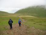
Sat 11 Aug 2007 - Newlands Hause to Buttermere
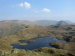
Newlands Hause - Knott Rigg - Ard Crags - Sail Pass - Sail - Eel Crag (Crag Hill) - Grasmoor - Wandope - Thirdgill Head Man - Whiteless Edge - Saddle Gate - Whiteless Pike - Whiteless Breast - Buttermere Village [8.00 miles 3,150ft ascent]
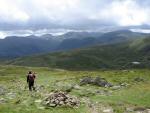
Sat 28 Jul 2007 - Keswick to Newlands Hause
Moot Hall, Keswick - Portinscale - Cumbria Way - Hawes End - Skelgill Bank - Catbells - Hause Gate - Maiden Moor - Blea Crag Cairn - High Spy - Dalehead Tarn - Dale Head - Hindscarth Edge - Hindscarth - Littledale Edge - Robinson - Buttermere Moss - Newlands Hause [11.75 miles 4,250ft ascent]
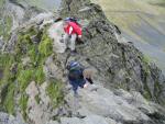
Sat 26 May 2007 - Scales to Keswick
Scales - above Mousthwaite Comb - Scales Tarn - Sharp Edge - Blencathra - Hall's Fell Ridge - Gategill - Threlkeld - Keswick Railway footpath - Moot Hall, Keswick [8.25 miles 2,250ft ascent]
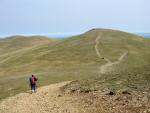
Sat 28 Apr 2007 - Patterdale to Scales
Patterdale - Striding Edge - Helvellyn - Helvellyn Lower Man - White Side - Raise - Sticks Pass - Stybarrow Dodd - Watson's Dodd - Great Dodd - Calfhow Pike - Clough Head - White Pike - Mariel Bridge - Lobbs - Wallthwaite - Scales [15.50 miles 4,450ft ascent]
Sat 14 Apr 2007 - Windermere to Patterdale
Windermere Railway Station - Orrest Head - Dubbs Reservoir - Dubbs Road - Garburn Road - Garburn Pass - Yoke - Ill Bell - Froswick - Thornthwaite Crag - High Street - Straits of Riggindale - The Knott - Satura Crag - Angle Tarn - Angletarn Pikes - Boredale Hause - Patterdale [15.00 miles 3,850ft ascent]