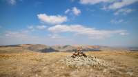
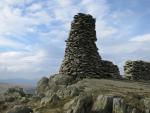
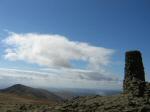
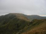
Rampsgill Head
Height: 792m/2,598ft
Grid Reference: NY443128
Lists: FRCC (042) Wainwright (FE.03)
Ascents: 11
Wainwright's Far Eastern Fells guide book published in 1957 states Rampsgill Head's height as 2,581ft but the OS 1:25,000 map now records 792m (2,598ft)
Sat 17 Apr 2021 - Mardale Head Round
Mardale Head - Haweswater - Riggindale - Kidsty Howes - Kidsty Pike - Rampsgill Head - Straits of Riggindale - High Street - Mardale Ill Bell - Nan Bield Pass - Harter Fell - Gatescarth Pass - Mardale Head [8.50 miles 3,010ft ascent]
Tue 1 Oct 2013 - Ten Fells from Hartsop
Hartsop - Brock Crags - Satura Crag - The Nab - Rest Dodd - The Knott - Rampsgill Head - High Raise - Kidsty Pike - Straits of Riggindale - High Street - Thornthwaite Crag - Gray Crag - Hayeswater - Hartsop [12.25 miles 4,050ft ascent]
Sat 29 Nov 2008 - High Street from Mardale Head
Mardale Head - Rough Crag - Caspel Gate Tarn - Long Stile - High Street - Roman Road - Straits of Riggindale - Rampsgill Head - Kidsty Pike - Kidsty Howes - Riggindale - Haweswater - Mardale Head [7.50 miles 2,435ft ascent]
Sun 16 Apr 2006 - High Street from Hartsop
Hartsop - Gray Crag - Thornthwaite Crag - High Street - Straits of Riggindale - Rampsgill Head - The Knott - Rest Dodd - The Nab - Satura Crag - Brock Crags - Hartsop [10.75 miles 3,750ft ascent]
Sat 2 Jul 2005 - High Street Roman Road (BROCAVVM to GALAVA)
Brougham Castle (BROCAVVM ROMAN FORT) - Brougham Hall - Eamont Bridge - Yanwath - Tirril - Winder Hall Farm - Moor Divock - The Cockpit - Loadpot Hill - Wether Hill - Red Crag - Raven Howe - High Raise - Rampsgill Head - Straits of Riggindale - High Street - Thornthwaite Crag - Scot Rake - Hagg Gill - Troutbeck Park - Ing Lane - Troutbeck - Robin Lane - Jenkin Crag - GALAVA ROMAN FORT (Ambleside) [23.50 miles 4,100ft ascent]
Sat 14 May 2005 - The Nab plus ten (A Martindale Round)
St. Peter's Church (Martindale) - Steel Knotts - Wether Hill - Red Crag - Redcrag Tarn - Raven Howe - High Raise - Kidsty Pike - Rampsgill Head - The Knott - Rest Dodd - The Nab - Satura Crag - Brock Crags - Angle Tarn - Angletarn Pikes - Beda Fell - Winter Crag - St. Peter's Church [14.25 miles 4,400ft ascent]
Sun 17 Apr 2005 - High Street from Mardale Head
Mardale Head - Small Water - Nan Bield Pass - Mardale Ill Bell - High Street - Straits of Riggindale - Rampsgill Head - Kidsty Pike - Kidsty Howes - Riggindale - Haweswater - Mardale Head [7.75 miles 2,385ft ascent]
Sun 15 Feb 2004 - High Raise and High Street from Mardale Head
Mardale Head - Haweswater - Riggindale - southeast ridge - Low Raise - High Raise - Kidsty Pike - Rampsgill Head - Straits of Riggindale - High Street - Long Stile - Caspel Gate Tarn - Rough Crag - Mardale Head [8.75 miles 2,700ft ascent]
Sat 21 Sep 2002 - Kidsty Pike and High Street
Mardale Head - Haweswater - Riggindale - Kidsty Howes - Kidsty Pike - High Raise - Rampsgill Head - Straits of Riggindale - High Street - Mardale Ill Bell - Nan Bield Pass - Small Water - Mardale Head [8.50 miles 2,780ft ascent]
Sat 14 Aug 1993 - Ramps Gill Round
Martindale Old Church - Loadpot Hill - Wether Hill - Red Crag - High Raise - Kidsty Pike - Rampsgill Head - The Knott - Rest Dodd - The Nab - Martindale Old Church [12.75 miles 3,285ft ascent]
Wed 30 Dec 1992 - Far Eastern Fells
Hartsop - Hartsop Dodd - Caudale Moor (Stony Cove Pike) - Threshthwaite Mouth - Thornthwaite Crag - High Street - Rampsgill Head - Kidsty Pike - The Knott - Hartsop [9.50 miles 3,600ft ascent]